
HD Maps for the Masses
The future of navigation will be centralized around HD maps. While plenty of companies exist to provide this type of data, all are limited by paywalls and strict Terms-of-Service. It is time for this… The future of navigation will be centralized around HD maps. While plenty of companies exist to provide this type of data, all are limited by paywalls and strict Terms-of-Service. It is time for this paradigm to change. Comma.ai is releasing US interstate HD maps from our 5,000,000+ miles of data.
HistoryPermalink
In the early 2000s, several navigation companies started creating maps of the US roadways; changing the way people thought about driving. However, the groups capable of creating these maps were restricted to those who had the finances. As time went on, and the internet matured, services such as Google Maps provided free access to their data. This was fine for your average consumer but licensing restrictions limited commercial use of map data. To quote OpenStreetMaps (OSM):
Most hackers around the world are familiar with the difference between “free” as in “free beer” and as in “free speech”. Google Maps are free as in beer, not as in speech.This ultimately led to the creation of projects such as OpenStreetMaps and corporate backers like Mapbox who help to maintain map integrity. As of 2018, the number of companies using open-source maps has grown as quality increases and prices for access to commercial data rise.
HD MapsPermalink
The next frontier of mapping is high-precision maps that are updated frequently. Yet the same problems seen in the infancy of the industry have re-materialized in HD mapping: either have the capital to build your own maps or concede to license someone else’s data. Properly building maps requires a significant amount of resources including a fleet of vehicles, processing power, and infrastructure. Meanwhile, purchasing a license to map data can be incredibly expensive.
But what even are HD Maps? Are they fundamentally different or is it just another buzzword thrown around in marketing departments? The data in OSM or Google Maps was primarily optimized for assisting humans, resulting in an over simplified and abstract representation of the world. Self-driving cars have generated an entirely new set of requirements. HD maps used for self-driving need to be a complete centimeter-accurate depiction of the real world, containing all things relevant to road navigation such as lanes, curvature and road boundaries.
Comma.ai uses fleet data from EON and Grey Panda to build an accurate representation of highways throughout the United States. Therefore, as our fleet grows, the likelihood of our maps representing the real world increases. The end result is a map that is not only open and decimeter accurate, but also up-to-date. As of today, 75,000+ miles of roadways are updated per-week.
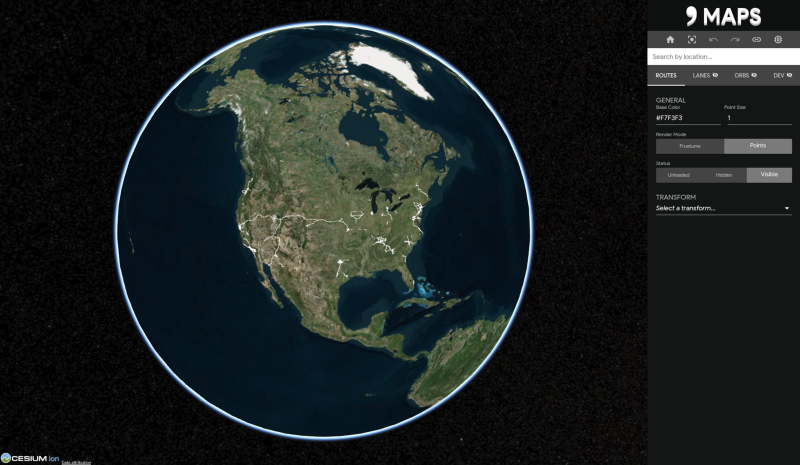
Comma MapsPermalink
In the future, we plan on making data available to the public. Since comma.ai’s initial announcement at the Mapbox conference, we have continued developing tools and infrastructure to facilitate building our maps.
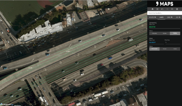
Our new map viewer, called “comma maps,” visualizes recorded paths driven, lane markings, and world features.
World Features from the Bay Bridge
In addition to a viewer, we also created infrastructure to tile our data. These tools are also being open-sourced, feel free to check out our project — entium — if you are interested in our tiling process. (Shout-out to Cesium and entwine for providing awesome open-source tools that helped make “comma maps” possible)
When can I get access?Permalink
Follow us on Twitter @ comma ai for updates and announcements regarding data availability. Also, if you are interested in helping grow the mapping network, grab an EON devkit with Grey Panda from comma.ai/shop
Leave a comment